
Proposed Permanent Road Reserve (Footpath) Closure - 21 Pomona Road
Consultation has now concluded
What is being proposed?
Council is seeking to undertake a road closure process for portion of the road reserve that adjoins the property at 21 Pomona Road, Stirling. The land owners have approached Council to correct a boundary anomaly. Under the Roads (Opening and Closing) Act 1991, public consultation is a requirement of the road closure process.
Council is seeking to realign the existing road reserve to rectify a boundary anomaly adjacent to the property located at 21 Pomona Road, Stirling. Please refer to the detailed report including plans of the site is available in the document library to the right of this page.
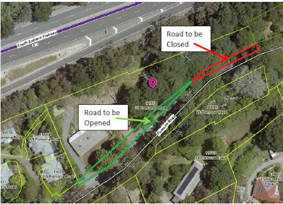
The existing road alignment is shown in Diagram A. The proposed road alignment is shown in Diagram B.
The Preliminary Plan identifying the road to be closed and the land to be opened as road is included as Plan A.
A road exchange process is required to facilitate the realignment of the road reserve with the adjoining land owner under the Roads (Opening & Closing) Act 1991. The road exchange will result in a section of road reserve being closed as public road (marked red on Diagram B) and amalgamated with the adjoining land and a section of the adjoining land owner’s land being opened as public road (marked green on Diagram B).
Why your feedback matters?
We want to know if the community and stakeholders have any concerns or objections, or are in support of the proposed road closure.
What happens to your feedback?
The feedback from the community and interested stakeholders will be included in a report taken to Council, which will enable the elected members to make an informed decision in determining if this project proceeds.
How can copies of the proposal be accessed?
Please refer to the detailed report including plans of the site is available in the document library to the right of this page.
A copy of the plan and a statement of persons affected are also available for public inspection at the offices of the Council at 63 Mt Barker Road, Stirling, between the hours of 8.30am and 5.00pm, Monday to Friday,
or at the Adelaide office of the Surveyor-General, 101 Grenfell Street, Adelaide, during normal office hours. The Preliminary Plan can also
be viewed at http://www.sa.gov.au/roadsactproposals
Any application for easement or objection must be made in writing to the Council at PO Box 44 Woodside SA 5244 WITHIN 28 DAYS OF THIS NOTICE and a copy must be forwarded to the Surveyor General at GPO Box 1354, Adelaide 5001 setting out full details. Where a submission is made, the Council will give notification of a meeting at which the matter will be considered, so that the person making the submission or a representative may attend, if so desired.
Any enquiries regarding the proposal should be directed to Council’s Natalie Westover on 8408 0546 or email nwestover@ahc.sa.gov.au
To leave your feedback or lodge an objection please complete the form below.
Please have your say by 28 October 2020